Road sign management system is to manage road signs and analyze it for the appropriateness of location and guide information. Through review/supplement application and various statistics function, it can be used for overall understanding of road sign information status and a basis of policy decision. In addition, in order to properly manufacture, install and maintain road signs, road sign designs are standardized by each type so that the systematic and reasonable road sign automatic design program(RoadGuider) is developed. (www.roadsign.go.kr)
Road sign is an important road attachment that maximizes the efficiency of road use as well as securing safe and smooth road traffic by providing directions, distances, route guide and other information to the road user such as the driver of the vehicle. The road sign system(management system & guide system) is a system that can perform and query the overall management of road signs operated by the road sign operation center of KOREA INSTITUTE of CIVIL ENGINEERING and BUILDING TECHNOLOGY. DBNtech conducts the maintenance of the system & the improvement of functions according to the diverse needs of the users for the smooth operation of the road sign system, and we also fulfill the renewal of the road network map which serves as the basis for system operation. In particular, we have advanced the road sign system to a linear-based management level and have developed the system to support decision making on reinforcement of analytical functions utilizing linearity and new road sign design. The road sign system divided into a road sign management system (www.korearoadsign.go.kr), which enables 300 road sign management institutions to input and manage road signs and a road sign guide system (www.roadsign.go.kr) where ordinary people can search and inquiry road signs at all the times to provide service.
2) Linear-based management system
A linear-based road sign system is a system that links all road sign data to a line (route) of the road and manages the signs on a route basis. The advantage of a linear-based system is that it automatically links all the signs to the linear information on the road, by matching consistent information from the road linear information, so it can improve error elimination & integrity and it is possible to distinguish between up-way and down-way according to the result of patch search and to ensure consistent data extraction.
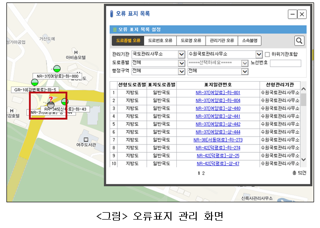
3) Detection function of a road sign with error
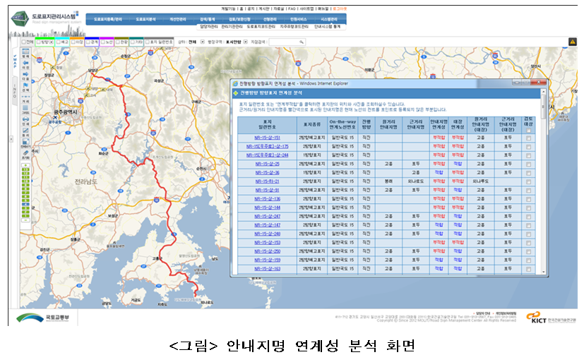
Detection of a road sign with an error is a function that allows local staff to more granularly check the list of the road signs they manage to detect potential errors such as road type, road number, road name, management institution, unknown and so on. A wrong road sign is displayed on the screen with the combination of red question mark icons and gray icons so that they can be distinguished from existing road signs. Also users can enter the management institution, road type, route number, and administrative area as search criteria to obtain the list of road signs including errors they want and the management function of wrong road signs has been enhanced by adding the search function of a road sign with an error according to each administrative area.
4) Decision support system
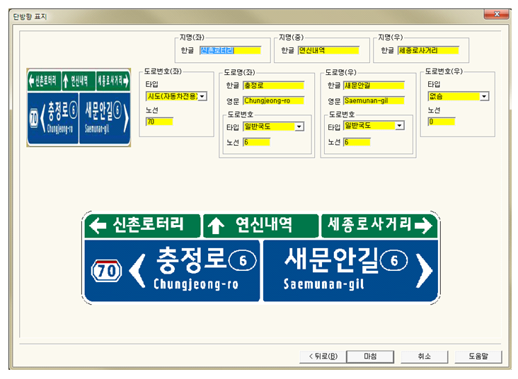
If you want to create a new road sign, this function will automatically show not only a guide name but also sign standard, installation location and so on. Based on the function, it can inspect a guide name and sign standard from existing input signs using road linear information. In addition, the functions to display the surrounding distance at intersections and determine if the location of the road sign is appropriate within that distance can also be more accurately calculated with the road linear information.
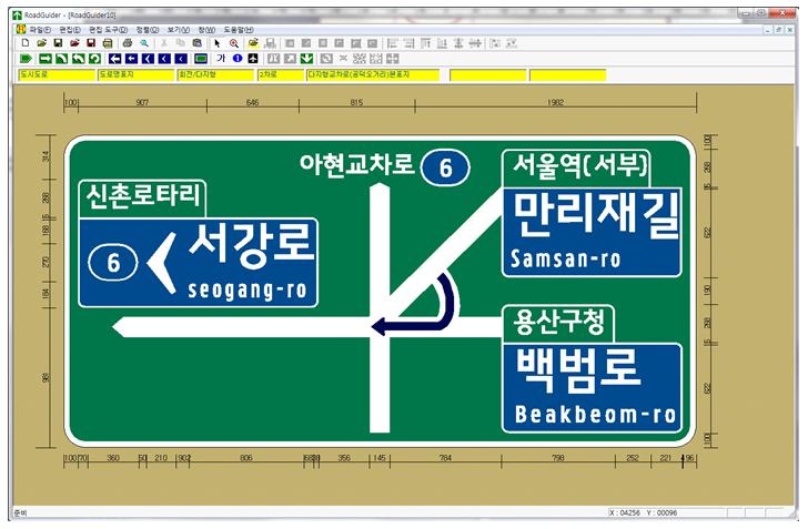
5) Road sign design program(RoadGuider)
In order to properly manufacture, install, and maintain road signs, an in-depth review and implementation should be carried out from the planning and design stages according to relevant laws and regulations. Therefore, RoadGuider, a road sign design program, was developed as a program to standardize a road signs design by type to establish a systematic and rational road guide system. In addition to road signs of existing guide names, RoadGuider applies the basic form and system of road signs, so the road management officials who produce, install and manage road signs can create and manage road signs more conveniently and systematically.